
Environmental Monitoring Solutions
We provide high-precision instruments for monitoring air quality, noise, water pollution, and meteorological parameters. Our solutions cater to industries, government agencies, and research institutions that require accurate, real-time data for environmental compliance, audits, and reporting. All equipment comes with support for installation, training, and data integration.

Custom Software & AI Tools
Our software team builds intuitive platforms powered by automation and AI — from invoicing systems and monitoring dashboards to full-fledged SaaS products.
We specialize in developing scalable web and mobile applications tailored to your business logic, industry needs, and user experience expectations. We also build AI models for industry-specific use cases like predictive maintenance and report generation.
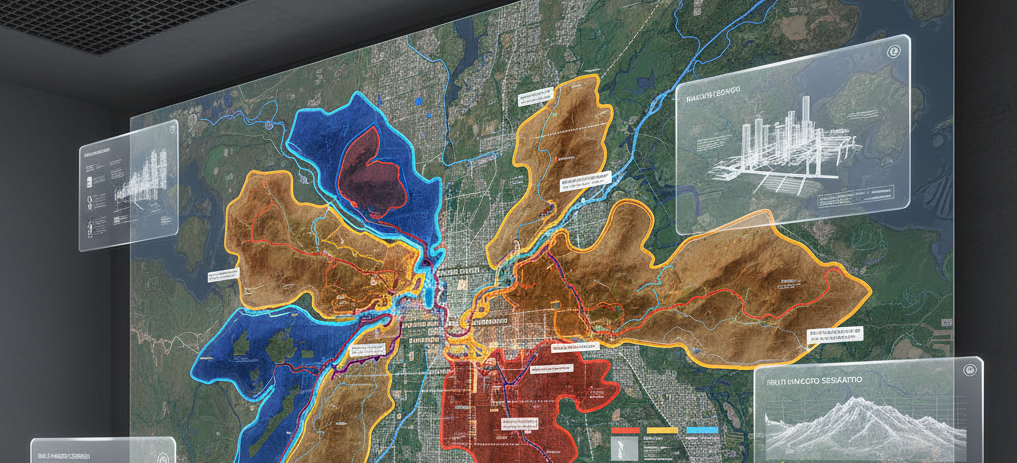
GIS & Mapping Solutions
We deliver advanced Geographic Information System (GIS) services that help visualize, analyze, and interpret spatial data.
Our expertise includes utility mapping, land use planning, biodiversity mapping, and spatial analysis for infrastructure, industrial planning, and disaster resilience. Using industry-standard tools, we transform complex data into actionable geographic insights.
Agriculture
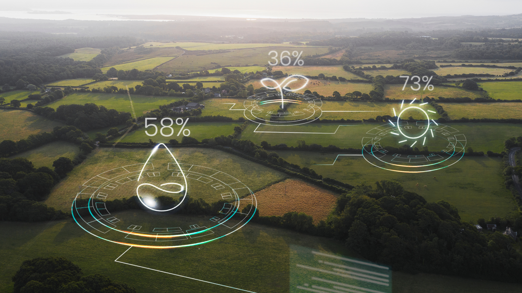
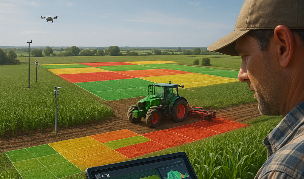
Geographic Information Systems (GIS) play a pivotal role in transforming agriculture by enabling farmers to map, organize, and analyze field data with high precision.
Through remote crop monitoring and data visualization, GIS supports the identification of trends, spatial patterns, and anomalies, allowing for timely interventions and improved crop management.
Precision agriculture, in particular, leverages GIS to handle large volumes of geospatial data, facilitating informed, data-driven decisions that enhance productivity sustainability.
At Atmospark, our mission is to advance sustainable agricultural practices by
integrating cutting-edge GIS technologies.
We aim to future-proof ecological systems while driving economic efficiency across farming operations.
By optimizing agricultural workflows and delivering actionable insights, GIS empowers stakeholders at every level from growers to agronomists to make smarter, more resilient decisions for the future of food production.
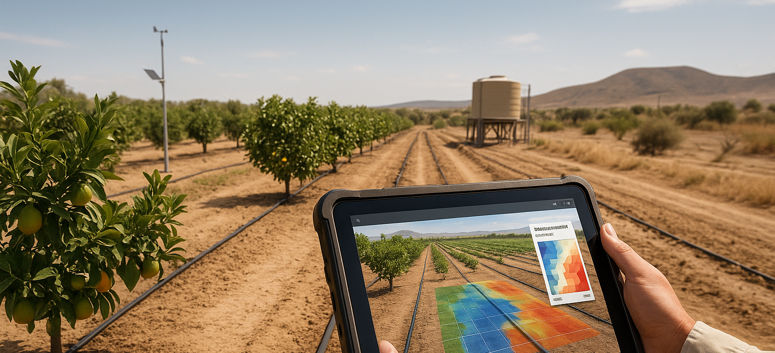
PRECISION IRRIGATION IN ARID ZONES
GIS technology plays a crucial role in the design and implementation of efficient irrigation systems by analyzing key factors such as terrain, soil characteristics, and crop water requirements. By accurately identifying zones with varying water needs, GIS enables precise irrigation planning minimizing water waste, enhancing resource efficiency, and supporting long-term conservation efforts.
At Atmospark, we harness the power of GIS and remote sensing to deliver precision irrigation solutions tailored for arid and water-sensitive agricultural zones. We monitor crop water demand and generate detailed evapotranspiration.
maps to optimize irrigation scheduling drastically reducing water use in crops like citrus and olives.
Our GIS-basedmapping integrates critical variables such as soil type, slope, moisture levels, and plant water stress to ensure balanced and effective water distribution.
We also provide detailed soil mapping services, analyzing properties such as texture, moisture content, and organic matter. When combined with crop requirements and weather forecasts, this data allows farmers to make informed. site-specific decisions about irrigation, fertilization, and crop rotation-ultimately increasing yields and promoting sustainable resource management.

DATE PALM HEALTH MONITORING
We provide specialized remote sensing solutions for monitoring the health of date palm plantations, with a focus on early detection and targeted intervention. Using high-resolution satellite imagery, we identify signs of disease, pest infestations, and water stress across extensive cultivation areas including regions like Al-Hasa and Oassim. Our approach combines multispectral and thermal analysis, vegetation indices, and temporal monitoring to detect subtle changes in canopy health. These insights enable plantation managers to respond proactively, optimize irrigation and pest control, and minimize crop losses. By delivering spatially accurate health assessments, we support data-driven decision-making that enhances productivity, reduces resource waste, and ensures the sustainable management of valuable date palm resources.
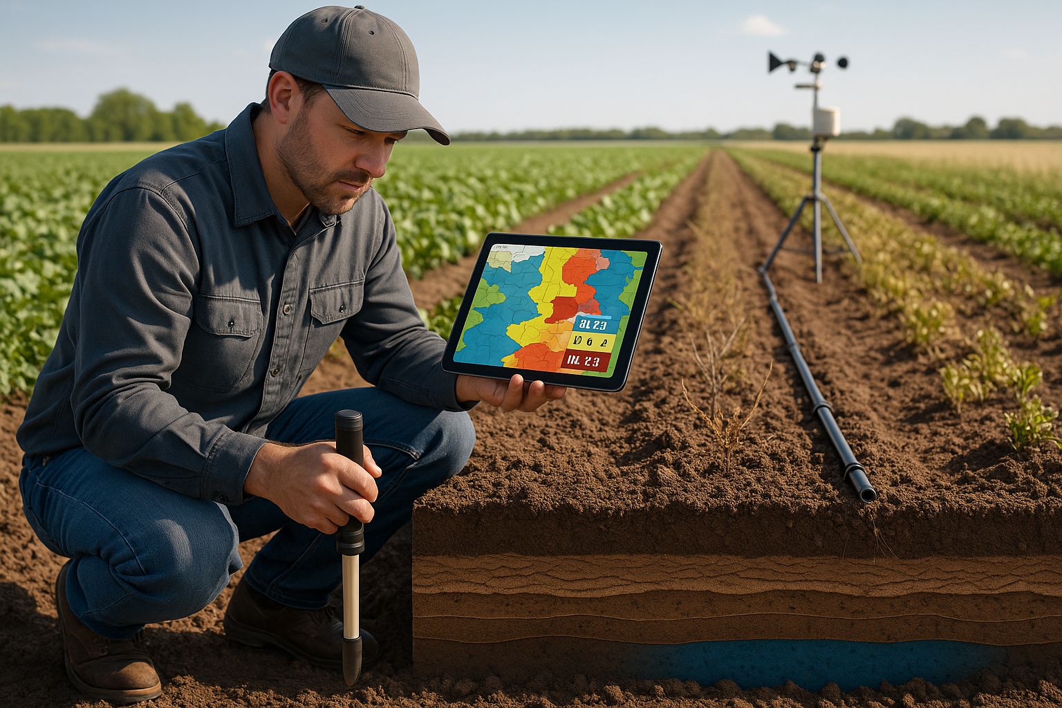
SOIL MAPPING AND SALINITY ASSESSMENT
At Atmospark, we offer advanced soil mapping and analysis services to support precision agriculture and sustainable land management.
Our solutions evaluate key soil properties-including texture, moisture content, and organic matter-providing farmers with actionable insights for site-specific decisions on irrigation, fertilization, and crop rotation. In addition, we specialize in soil salinity mapping using indicators such as the Salinity Index (si) to identify affected zones, assess their impact on crop yield, and guide irrigation and land reclamation strategies. By correlating salinity patterns with farming practices, we help
optimize crop selection, improve productivity, and promote long-term soil health.
Disaster management
At Atmospark we are at the forefront of applying Geographic Information Systems (GIS) and Remote Sensing (RS) technologies to mitigate the impacts of natural and man-made disasters. Our expertise translates complex geospatial data into actionable intelligence, empowering decision-makers from the strategic planning phase through to emergency response and long-term recovery.
We offer a comprehensive suite of technical services tailored to the unique challenges of each hazard type.
Disaster Prevention & Risk Assessment
The foundation of resilience is understanding risk. Our services transform complex data into actionable intelligence.
- Hazard Zonation Mapping:
We create detailed maps identifying areas susceptible to floods, landslides, earthquakes, wildfires, and other hazards using advanced spatial analysis and historical data.
- Vulnerability & Risk Analysis:
We integrate data on population density, infrastructure, land use, and building types with hazard maps to quantify potential impacts and identify high-risk zones.
- Multi-Hazard Scenario Modeling:
We simulate various disaster scenarios to visualize potential impacts, helping clients understand worst-case outcomes and prioritize mitigation efforts.
We provide end-to-end geospatial solutions that empower governments, emergency services, insurance companies, and communities to make critical decisions with confidence.
Our Suite of Disaster Management Services
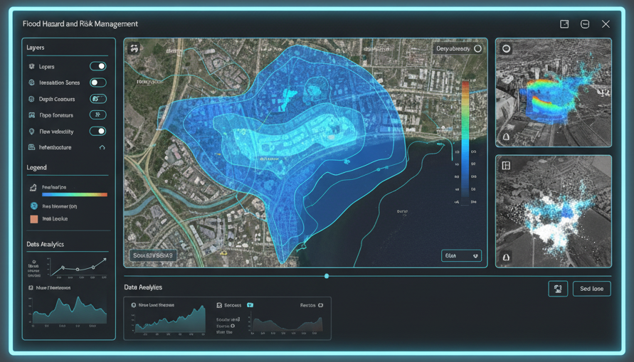
1. Flood Hazard & Risk Management
We provide end-to-end solutions for flood preparedness, response, and mitigation, leveraging the synergy of satellite data and hydraulic modeling within a dynamic GIS environment.
- Hydrological & Hydraulic Flood Modeling
We develop high-precision 2D and 3D finite element models for predicting flood inundation in river channels and floodplains. These models are powered by high-resolution Digital Elevation Models (DEMs) derived from LiDAR, aerial photography, and satellite sources like SPOT.
We provide Detailed flood hazard zonation maps indicating depth, duration, flow velocity, and recurrence intervals. These are integrated with cadastral, population, and infrastructure data for precise risk assessment and insurance modeling.
- Near-Real-Time Flood Monitoring & Damage Assessment
We utilize Synthetic Aperture Radar (SAR) data from satellites like RADARSAT and ERS for all-weather, day-and-night monitoring of inundation areas during flood events. Our automated processing chains include speckle filtering and change detection algorithms to compare pre-flood and during-flood SAR imagery.
It is useful for rapid delineation of flooded areas to guide emergency response, even under persistent cloud cover. Post-event, we conduct damage assessment by analyzing the spatial correlation between inundated areas and high-value assets.
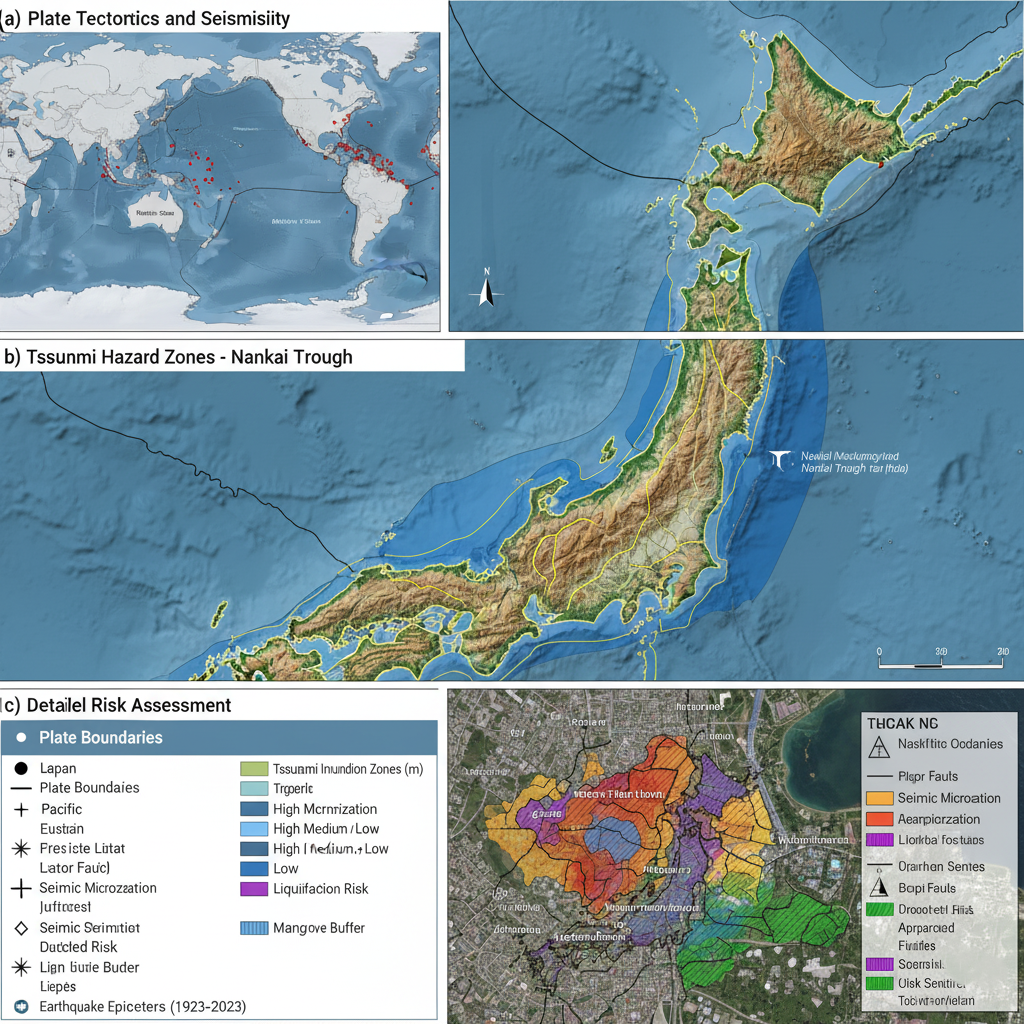
2. Seismic & Tsunami Risk Analysis
Our services focus on understanding and preparing for ground shaking, its secondary effects, and tsunami inundation.
We conduct large-scale (1:10,000 to 1:25,000) GIS-based analyses to model the local amplification of seismic waves. This involves integrating data from seismic networks, accelerometers, geotechnical boreholes, and detailed topographic models.
Maps detailing variations in ground shaking intensity, liquefaction potential, and landslide susceptibility specific to local soil and geological conditions. These are critical for updating building codes and prioritizing retrofitting programs.
- Tsunami Inundation Modeling & Zonation
We model potential tsunami run-up and inundation zones using coastal DEMs and ocean floor bathymetry. A key input is a geomorphological interpretation of coastal terrain using stereo SPOT imagery and Landsat TM data to classify terrain units based on elevation above mean sea level and "roughness" (e.g., presence of mangrove forests, which significantly dampen wave energy).
Defining evidence-based evacuation zones and planning vertical evacuation structures for coastal communities.
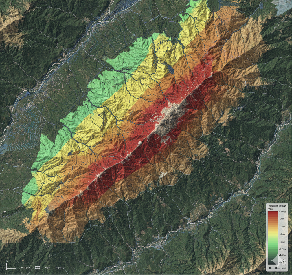
3. Landslide Susceptibility Zonation & Monitoring
We offer statistically robust methods to identify and prioritize areas prone to slope failures.
- Heuristic & Statistical Landslide Hazard Modeling
Expert-driven weighted overlay analysis based on geomorphological mapping. Information Value, Weights of Evidence, and Landslide Susceptibility analysis to calculate weight values for factor classes (lithology, slope, land use) based on historical landslide densities.
Multivariate Statistical: Discriminant Analysis and Logistic Regression performed on grid-based or terrain unit-based sampling to identify the controlling factor combinations. We create detailed factor maps from satellite imagery (lithology, land use, faults), DEM derivatives (slope, aspect, curvature), and rainfall data.
For critical infrastructure projects, we employ deterministic models like the infinite slope model within a GIS framework. This requires integrating geotechnical parameters (soil cohesion, friction angle) with groundwater simulation models to calculate factors of safety for specific slopes.
4. Wildfire & Coal Fire Management
Our services address fire risks from vegetation and underground sources.
- Fuel Load Mapping & Fire Risk Modeling
We use time-series data from NOAA/AVHRR, SPOT/VEGETATION, or MODIS to map vegetation types, condition, and stress levels. This fuel load data is integrated into GIS models like FIREMAP, along with topographic and meteorological data (wind speed, direction, humidity), to calculate fire spread rate, fireline intensity, and direction of maximum spread.
- Active Fire Detection & Burn Scar Assessment
We utilize the mid-infrared channel (3.7 µm) of AVHRR and other sensors for automated hot spot detection. Post-fire, we use Normalized Difference Vegetation Index (NDVI) analyses from Landsat and SPOT to precisely map burn scars, assess ecological damage, and monitor regeneration over time.
- Coal Fire Detection & Monitoring
Using thermal infrared data (e.g., Landsat TM band 6, ASTER), we detect surface and subsurface coal fire anomalies. We employ advanced techniques, including DEM-based solar incidence angle modeling to correct for non-uniform heating, to pinpoint fire locations and monitor their expansion or containment over time.
Our Expertise Across Disaster Types
Our methodologies are tailored to the unique challenges of each hazard:
Floods: Hydrological modeling, inundation mapping, and integration of real-time rainfall data.
Landslides: Susceptibility mapping using geological, slope, and land-use data, combined with statistical and deterministic models.
Wildfires: Fuel load mapping, monitoring active fires and smoke plumes, and post-fire burn scar analysis.
Earthquakes: Seismic microzonation, liquefaction potential mapping, and analysis of ground deformation using advanced techniques.
Drought: Monitoring vegetation health and agricultural stress over time using satellite-derived indices.
Environment
Innovative Geospatial Solutions for Sustainable Development in the Middle East.
The Middle East faces a unique set of environmental challenges—ranging
from rapid industrial growth and urban expansion to fragile coastal
ecosystems, scarce freshwater resources, and increasing climate extremes.
Our Environmental GIS Services combine satellite data, spatial analysis,
field validation, and cutting-edge modeling to help governments, industries,
and developers meet sustainability goals, comply with regulations, and
protect natural resources.
We align our work with Saudi Vision 2030, the UAE Green Agenda, and other
regional sustainability frameworks to ensure your projects deliver both
economic growth and environmental stewardship.
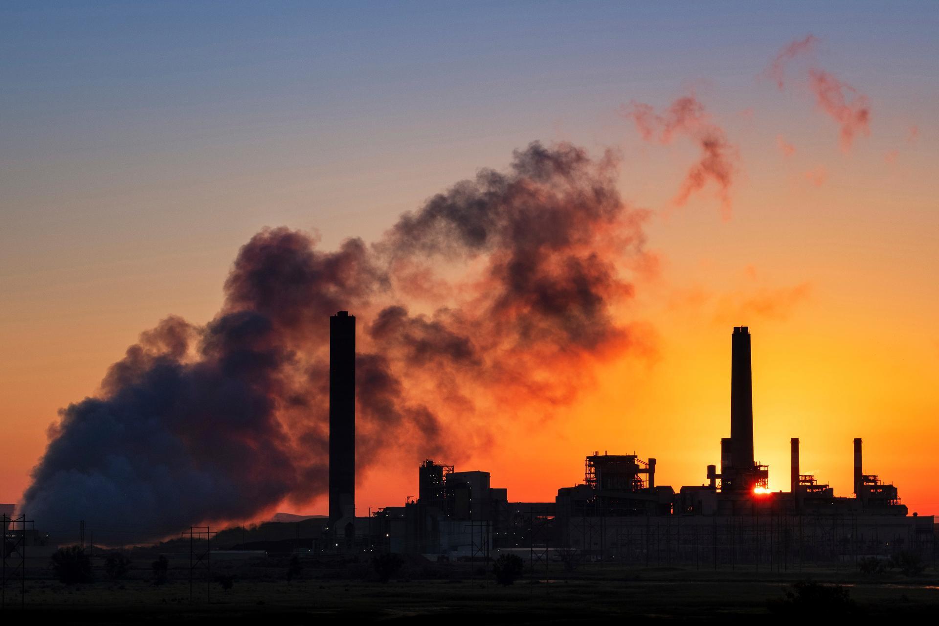
POLLUTION CONTROL & MONITORING
We provide advanced GIS-based solutions to detect, monitor, and mitigate pollution in air, water, and soil. Our services track industrial emissions, urban runoff, and hazardous spills, enabling fast and informed responses.
- Air & Water Quality Monitoring using real-time data feeds and spatial analysis.
- Pollution Source Identification for industrial discharge, transportation hubs, and high-risk areas.
- Air Dispersion Modeling with AERMOD to simulate pollutant spread under varying weather conditions.
- Hotspot Mapping to prioritize mitigation actions
Applications: Industrial clusters, oil & gas operations, environmental regulators
ENVIRONMENTAL IMPACT ASSESSMENTS (EIA)
We support giga-projects, urban infrastructure, and industrial developments in meeting environmental compliance while enabling sustainable growth.
- Spatial Modeling & Suitability Analysis to guide project site selection
- Buffer Zone Impact Assessments for sensitive habitats and communities
- Land-Use/Land-Cover Change Detection using multi-temporal satellite imagery
- Habitat Risk Modeling for biodiversity-sensitive regions
Applications: Roads, renewable energy, industrial parks, tourism masterplans
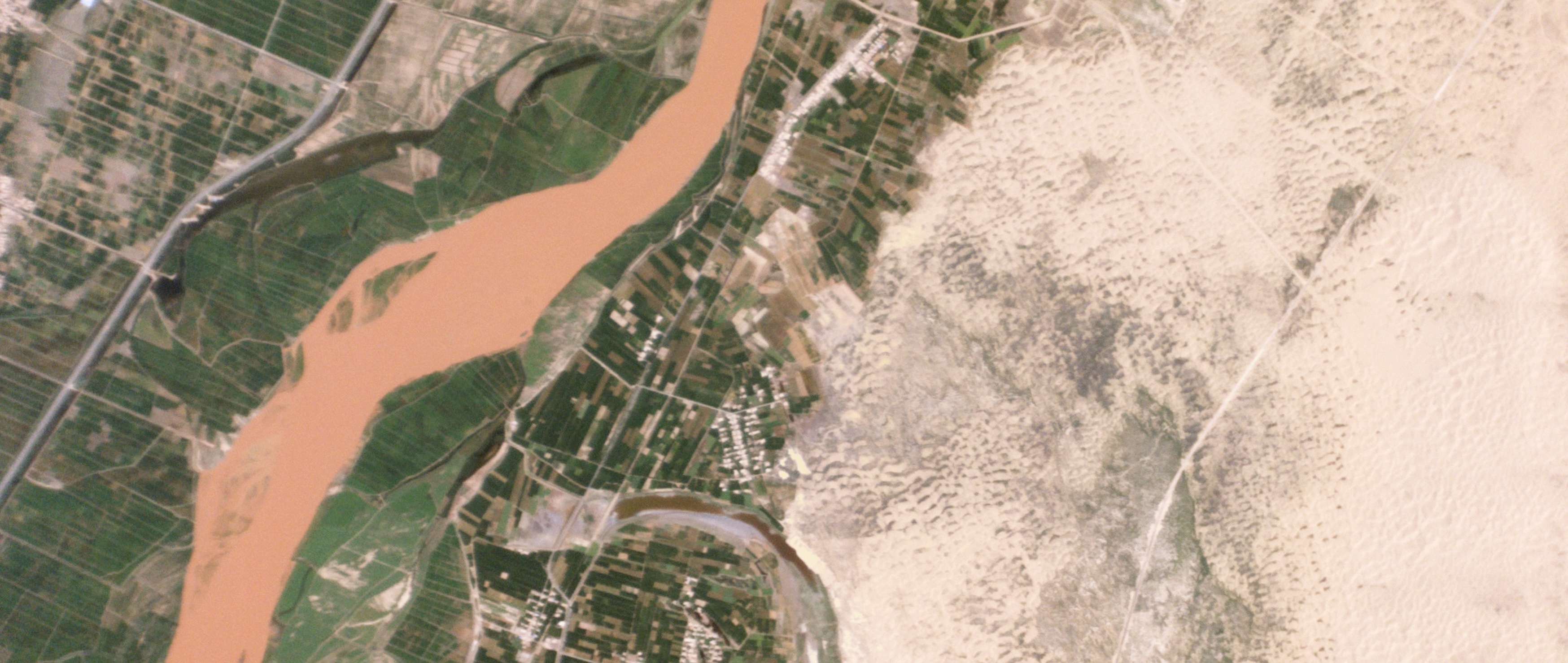
LAND DEGRADATION & DESERTIFICATION MONITORING
Desertification is a critical threat in arid Middle Eastern landscapes. Our GIS solutions help track and reverse land degradation trends.
- Vegetation Indices (NDVI/NDMI) to assess plant health and drought stress
- Soil Erosion Modeling using Digital Elevation Models (DEMs)
- Satellite-Based Land Degradation Mapping with MODIS, Landsat, Sentinel data
- Mobile GIS Field Surveys for validation and restoration planning
Applications: Rangeland conservation, agricultural productivity, afforestation programs
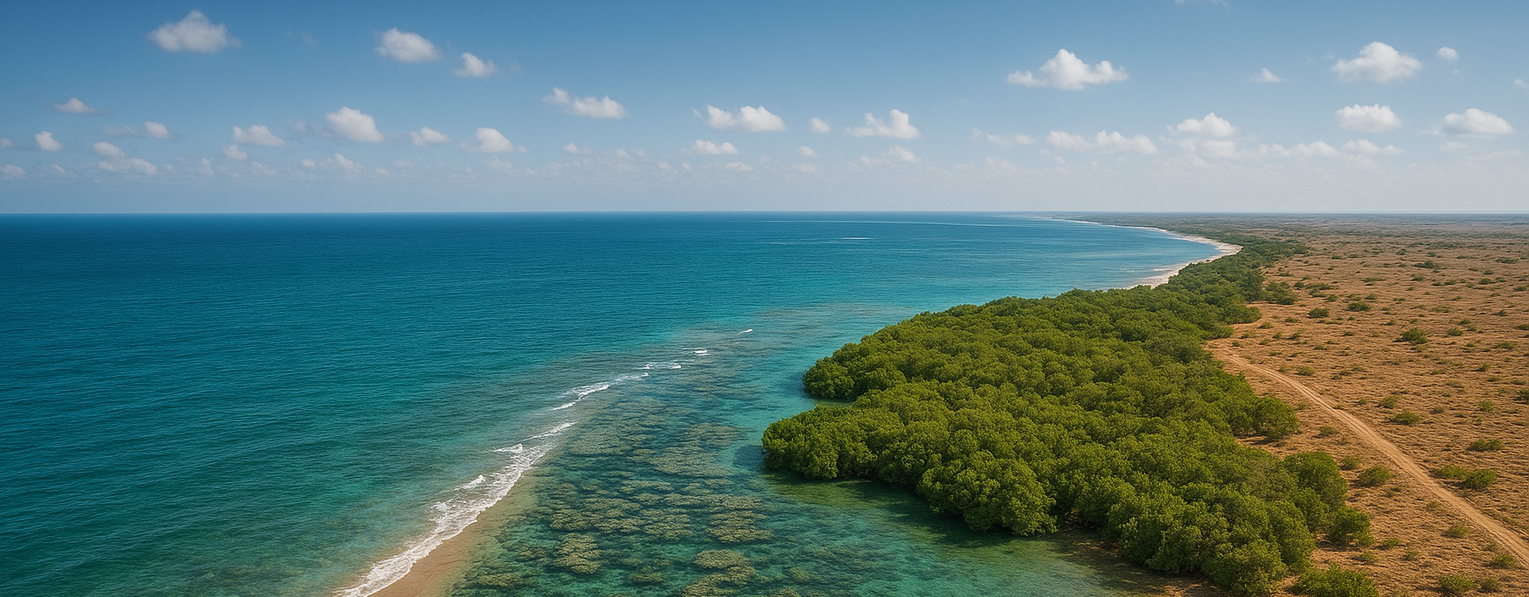
COASTAL & MARINE ENVIRONMENT MONITORING
With the Arabian Gulf and Red Sea under growing ecological pressure, we provide high-resolution monitoring for marine and coastal ecosystems.
- Shoreline Change Detection for erosion and reclamation monitoring
- Coral Reef & Mangrove Mapping using multispectral imagery
- Oil Spill Detection with Synthetic Aperture Radar (SAR)
- Coastal Flood & Storm Surge Modeling for resilience planning
Applications: Port authorities, fisheries, marine protected area management
WATER RESOURCES & AQUIFER MAPPING
In water-scarce environments, sustainable groundwater and surface water management is essential. Watershed & Wadi Delineation for flood and recharge management
- Groundwater Potential Mapping integrating geology, RS data, and hydrology
- Water Quality Estimation via satellite-derived proxies
- Drought Risk Zoning using SPI, VHI, and climate data
Applications: Municipal water planning, irrigation optimization, dam safety
CLIMATE CHANGE VULNERABILITY ASSESSMENT
We help cities, industries, and planners prepare for climate extremes through spatial risk mapping.
- Urban Heat Island (UHI) Analysis using land surface temperature data
- Flood & Drought Vulnerability Zoning for infrastructure and communities
- Climate Scenario Modeling (RCPs) with GIS integration Risk Indexing for adaptive planning
Applications: Smart city design, infrastructure resilience, disaster risk reduction
BIODIVERSITY & PROTECTED AREA MONITORING
Our services safeguard ecological treasures by monitoring habitats, species, and protected landscapes.
- Habitat Suitability Modeling (e.g., MaxEnt) for threatened species
- Protected Area Boundary Mapping & Compliance Tracking Camera Trap Data Integration for species movement analysis
- Ecosystem Change Detection using satellite time series
Applications: Wildlife conservation, eco-tourism, habitat restoration
ENVIRONMENTAL COMPLIANCE & SMART MONITORING
We enable regulators and industries to meet environmental standards through technology-driven monitoring systems.
- Real-Time Dashboards (ArcGIS, Power BI) for environmental KPIs
- Mobile Inspection Tools (Survey123, Field Maps) for rapid data collection
- Time-Series Emission Tracking for pollution hotspots
- IoT-GIS Integration with air, noise, and water quality sensors
Applications: Industrial parks, regulatory agencies, compliance auditing
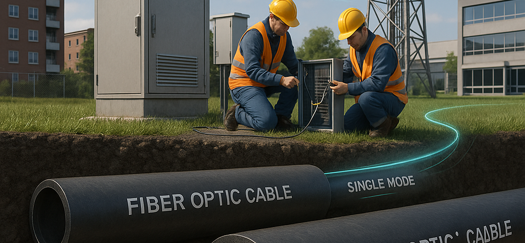
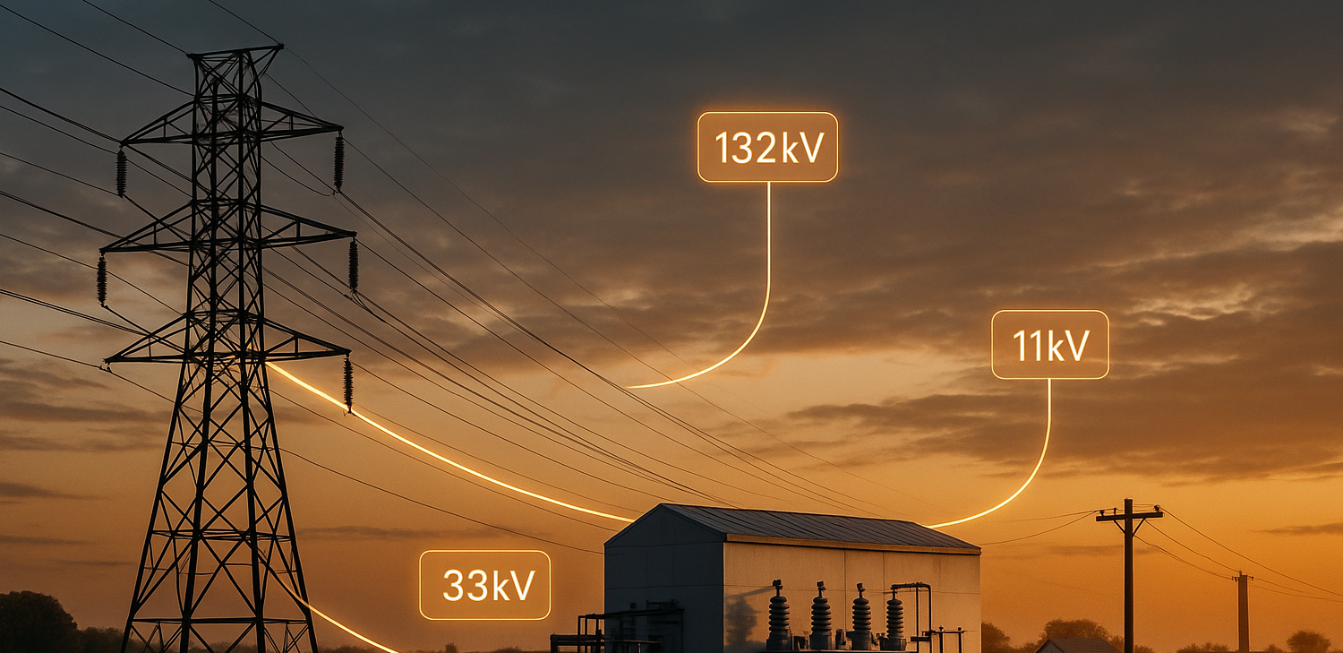
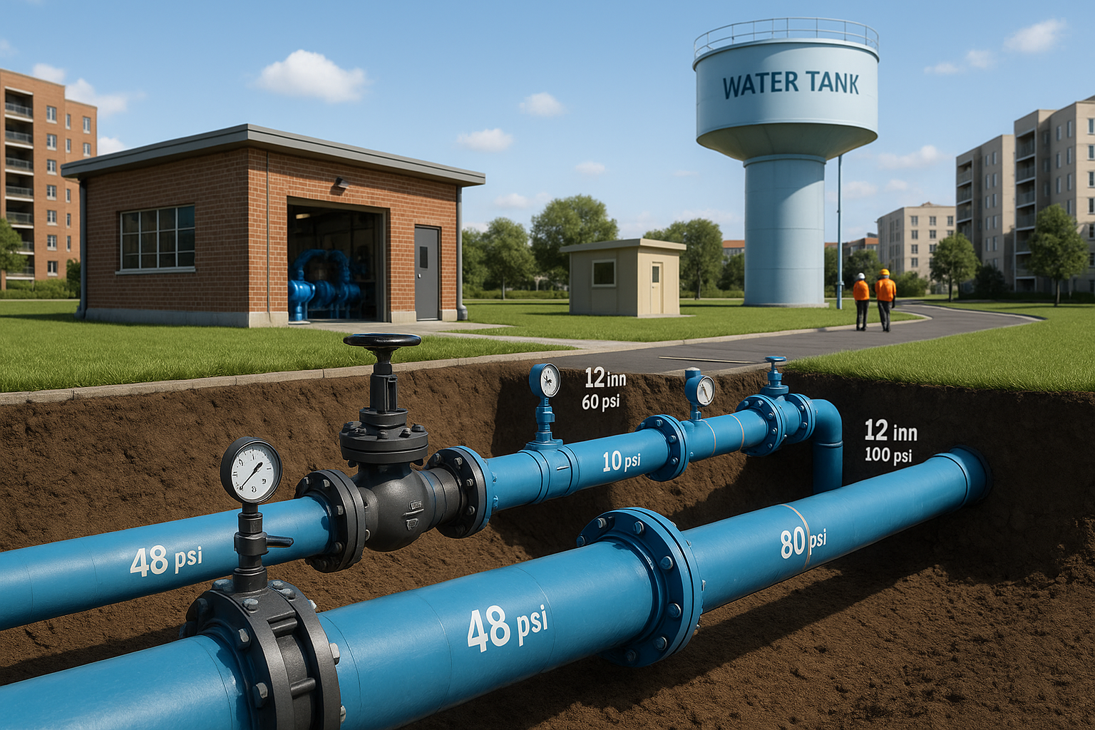
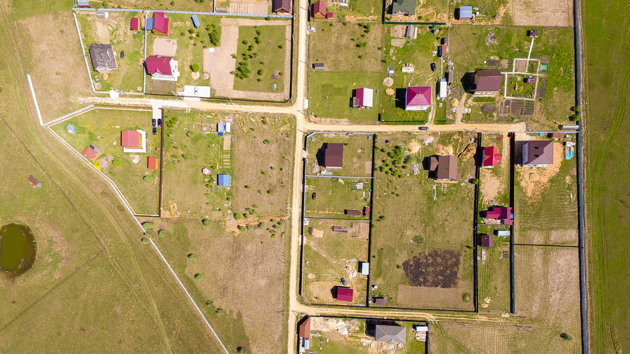
Utility Mapping & Management
Utility mapping and management involve the collection, visualization, and analysis of critical infrastructure such as electricity and telecom cables, water, gas, and sewage pipelines.
GIS enables organizations to clearly map these assets and optimize their entire network on a geospatial platform.
It plays a vital role in planning, managing, and maintaining utility networks efficiently.
Utility Network Data Migration
At Atmospark Technologies, we specialize in the seamless migration of utility-network data from ArcGIS Desktop (ArcMap) to ArcGIS Pro.
Our team ensures a smooth transition by:
1. Migrating datasets and configuring ArcGIS Pro’s modern Utility Network framework.
2. Re-creating schematic diagrams with updated templates.
3. Performing data-compatibility checks and error resolution.
4. Integrating attribute rules and handling bulk service migration to the ArcGIS Pro runtime.
Whether you’re upgrading infrastructure or modernizing GIS workflows, we provide end-to-end support to keep your network accurate, traceable, and future-ready.
Linear Utility Networks
Detailed GIS maps can be created for all major utilities, including:
- Electrical Networks: Transmission and distribution lines, substations, transformers, voltage information.
- Water Supply Systems: Pipelines with pressure and diameter data, valves, reservoirs, pumping stations.
- Gas Pipelines: Distribution lines, regulators, and stations.
- Sewage Systems: Sewer lines, manholes, treatment plants.
- Telecommunication Networks: Fiber optics, towers, and underground cables.
This utility data can be continuously updated as the network grows, supporting efficient planning, installation, maintenance, and repair.
Survey & Field Data Services
We offer a full range of ground-based and aerial survey services including DGPS, Total Station, Drone, and LiDAR surveys.
Our team ensures accurate, georeferenced data collection for civil engineering, smart cities, utilities, biodiversity assessments, and environmental projects. We also assist with data processing, visualization, and GIS integration.


